

I thought I knew Normandy before I ever set foot there. In my mind it was a collage of black‑and‑white D‑Day photos, a lone image of Mont‑Saint‑Michel at high tide and a vague promise of cider and Camembert. What I discovered on the ground was a region that kept changing character every time I drove over a hill or stepped off a train. This is my honest account of what surprised me when I finally traveled through Normandy, beyond the postcard icons and quick-stop itineraries.
Planning a Route That Looked Sensible on a Map (But Not Always on the Road)
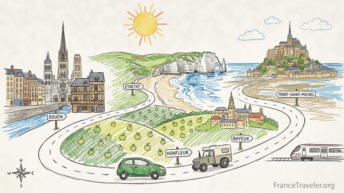
My trip began in Paris with a rental car reservation and an ambitious Google Map dotted with Rouen, Honfleur, Étretat, Bayeux, the D‑Day beaches, Mont‑Saint‑Michel and the rolling orchards of the Pays d’Auge. On paper it looked like a logical loop. On the road it taught me that Normandy is more spread out and slower to cross than it appears on a screen. Distances that looked like short hops became long two‑lane drives behind tractors or camper vans, and what I thought would be a relaxed circuit turned into a series of trade‑offs about where to linger and where to just pass through.
I decided to start without a car, taking an early SNCF train from Paris Saint‑Lazare to Rouen. Standard TER and Intercités services on this line run several times a day and take about 1 hour 20 minutes. From Rouen I picked up a compact rental car near the station, figuring I would return it later in Caen. That combination of rail into the region and car for the coastal and rural stretches turned out to be a good call. What I underestimated was how tiring it can be to drive narrow D‑roads after a full day of sightseeing, especially around the Côte d’Albâtre between Étretat and Fécamp, where views are wonderful but traffic and parking demand patience.
My biggest planning mistake was trying to link Étretat and Bayeux in a single driving day with detours. I routed myself Rouen–Étretat–Honfleur–Bayeux in one go because it looked like a scenic arc. It was scenic. It was also six solid hours of driving once I added in parking, wrong turns near Le Havre and a traffic jam on the Pont de Normandie. If I did it again I would either overnight in Étretat or Honfleur, or cut one of them on that transfer day and circle back later by train.
What maps do not show clearly is how Normandy’s character shifts as you move. Around Rouen the Seine valley feels urban and historic, with industry mixed into the riverbanks. Between Honfleur and the Pays d’Auge the landscape softens into orchards, half‑timbered farmhouses and horses in misty fields. Farther west around Bayeux and the D‑Day beaches the horizon opens, the wind picks up and the mood becomes more contemplative and sparse. Each zone deserves its own rhythm, and my attempt to see them all at one speed was my first wrong assumption.
Rouen: More Timeworthy Than I Allowed
Rouen was supposed to be my simple launch pad, but it immediately challenged my assumptions about Normandy’s cities. I expected a slightly somber stop dominated by Joan of Arc history. Instead I walked out of the station into a busy place layered with medieval, Renaissance and contemporary life. Half‑timbered houses lean over narrow streets, the Gros‑Horloge gleams above a shopping lane, and Rouen Cathedral rises like stone lace, all within a compact historic core that genuinely rewards aimless wandering.
I stayed one night at a small hotel just off the rue du Gros‑Horloge, which meant I could park the car in an underground public lot and explore on foot. Central parking garages are clearly signposted from the ring roads, but the one‑way system is not intuitive and I circled twice before committing to a ramp. The lesson here was simple: if you are driving into Rouen, download an up‑to‑date navigation app and be ready for tight turns into underground lots. Once parked, I felt no need to touch the car until departure.
Rouen surprised me with how strongly it tied into the Impressionist story that Normandy tourism emphasizes. In my mind, Impressionism meant coastal light and Monet at Giverny. In Rouen, standing in front of the cathedral that Monet painted in multiple series and then crossing the Seine to look back at the skyline, I started to see the region as a continuous canvas of river, city and sea rather than a collection of isolated sites. The weather helped; a mix of sun and fast‑moving clouds in late spring created exactly the kind of shifting light those painters chased.
If I could rewrite my itinerary, I would give Rouen two nights. That extra time would allow a morning in the museums, an evening stroll along the Seine quays and a slow coffee in the old market square where Joan of Arc was executed, instead of skimming all three between check‑in and an early start for Étretat.
Honfleur and Étretat: Beauty, Parking Lessons and Crowded Surprises
From Rouen I drove to Étretat via the D roads that weave through the chalk plateau. The closer I got to the coast, the narrower the roads became, edged by high hedgerows that blocked most views until the last minute. I rolled into Étretat late morning under bright skies, which meant two immediate realities: the cliffs were dazzling, and every obvious parking space was already taken.
Étretat has several official parking areas, including lots set slightly back from the waterfront. Paid parking rules have tightened in recent years, with tariffs updated in 2025 and a large part of the village designated as regulated parking. I eventually found a space in one of the upper car parks and walked down into town. The good part of this arrangement is that you arrive at the clifftop trails above the beach by foot, which gives you sweeping views. The frustrating part is budgeting time to hike back up when you are already tired. On a dry, clear day the path to the Falaise d’Aval felt safe, but with steep drops and no railings in places it would be very different in wet or windy conditions.
I misjudged how crowded Étretat would feel in shoulder season. Even outside peak summer, day‑trippers and bus groups filled the seafront, and the narrow streets quickly bottlenecked. I grabbed a simple lunch of moules‑frites and local cider at a brasserie just off the main promenade; prices hovered around what you would expect for a prime coastal village, slightly higher than in inland towns but not eye‑watering. What I regretted was not booking a night there. Once the buses leave and the day visitors trickle out, the light on the cliffs at sunset and early morning is supposed to be magical. My midday slice of Étretat was beautiful but rushed.
From Étretat I drove to Honfleur, crossing through Le Havre and over the Pont de Normandie. The bridge itself is a minor thrill, arching high over the Seine estuary with a toll plaza on the far side. Approaching Honfleur, traffic slowed to a crawl near the harbor. The town treats its historic center as a prized, protected site, and it manages parking accordingly. There are multiple public car parks around the perimeter, some in blue‑zone areas where stays are limited, and meters now work with mobile payment systems such as EasyPark. I parked in a long riverside lot with a view back to the Lieutenance tower, digging small coins out of my bag and wishing I had set up the app beforehand.
Honfleur itself felt instantly different from Rouen and Étretat. The old port is framed by tall, narrow houses whose facades catch every change in the sky, a scene painted so often that it already felt strangely familiar. Crowds were thick around the Vieux Bassin, yet I only had to step a few streets inland to find calm. I checked into a small guesthouse in a half‑timbered lane that creaked pleasantly with age, then walked back down for dinner. I chose a restaurant that specialized in local seafood and ordered scallops when they were in season, along with a carafe of crisp local cider. It was here that Normandy’s gastronomic identity really began to crystallize for me: butter‑rich sauces, cream, apples in many forms and seafood pulled almost directly from the estuary.
Bayeux and the D‑Day Beaches: History That Felt More Raw Than I Expected
My plan was to leave Honfleur after breakfast and be in Bayeux by lunchtime, with an afternoon free for the tapestry and an organized D‑Day tour the next day. The drive along the coast via Deauville and Courseulles‑sur‑Mer looked straightforward. In practice, weekend traffic near the resort towns and a detour around roadworks added nearly an hour. This was one of those days when I wished I had taken the train instead of driving.
There are fairly direct rail connections between Rouen and Bayeux with a change, usually in Caen, and SNCF’s published schedules show several trains on a Sunday taking around 2 hours 30 minutes. Arriving in Bayeux by train deposits you within walking distance of the medieval center, which is compact and flat. Because I arrived by car, I spent my first twenty minutes in town learning the logic of the one‑way streets and working out which public lot allowed overnight parking. Once parked, Bayeux was a joy on foot, quieter and more low‑key than I had imagined for such a famous name.
I stayed in a small hotel near the cathedral, waking to bells and the smell of baking from a neighborhood boulangerie. The Bayeux Tapestry, housed in a dedicated museum, operates with timed entry and extended hours during busy periods, especially around school holidays and the D‑Day commemorations that intensify each June. I had booked my ticket ahead, which spared me a wait. Standing at the glass case, tracing the embroidered story of the Norman conquest, I was struck by how much of Normandy’s identity is built on layers of conflict and crossing the Channel.
My D‑Day experience the next day was more emotional than I expected. I joined a small‑group minibus tour from Bayeux that visited Omaha Beach, the American Cemetery at Colleville‑sur‑Mer, Pointe du Hoc and one of the artificial harbor remnants at Arromanches. In 2026 the landing beaches were added to the UNESCO World Heritage List along with Pointe du Hoc, formal recognition of what anyone feels when they stand there in the wind: this coastline is more than scenery. There are still strict access rules around certain bunkers and cliff edges, and local guides keep a close eye on tides and changing weather conditions. On my visit a strong onshore wind whipped up sand and made it hard to hear at times, which somehow underscored the vulnerability of that open shore.
I had imagined that the beaches would be solemn but sparsely visited. In reality, tour buses, school groups and independent travelers created a steady flow even in the shoulder season. Yet people spread out along the wide sands, so the crowd rarely felt oppressive. The surprise for me was how quickly you can shift from a parking lot lined with souvenir stalls to a silent moment facing a row of white crosses, and then back into a cheerful cafe for a sandwich. The commercial and commemorative layers sit side by side, and it is up to each traveler to decide how to balance them.
Mont‑Saint‑Michel: Logistics, Shuttles and Why I Would Stay Overnight Next Time
From Bayeux I drove to Mont‑Saint‑Michel, exiting the main autoroute near Avranches and following increasingly busy feeder roads toward one of France’s most visited sites. My assumption was that I could park relatively close to the island, stroll across the causeway, visit the abbey and be back on the road by late afternoon. The reality in 2026 is more structured, and for good reason.
All visitor vehicles park on the mainland in a large complex of lots set back from the bay. Tariffs are set by the authorities and vary by season, hour and duration, with 2026 schedules detailing different price bands in winter, mid‑season and high season. From the parking area you can either walk along the wide causeway or take the free shuttle buses that run back and forth throughout the day. Official guidance from the site manager suggests allowing around one hour between leaving your car and reaching the abbey entrance at the top of the island, which felt accurate once I factored in the walk from the lot, a short shuttle wait and the steep climb through the medieval streets.
I arrived in mid‑afternoon under mixed skies, part blue with rolling white clouds and part heavy with showers. The streets inside the walls were at their busiest, and progress up the main lane felt like merging into a slow river of tour groups, student trips and day visitors. Entry to the abbey itself is ticketed, with recommended advance booking, and current information warns of security checks at the entrance. I passed through relatively smoothly but could see how in peak hours queues might build. Inside, the abbey is surprisingly serene, with stone cloisters and panoramic views over the bay that draw your eye away from the human bustle below.
Where I miscalculated was in treating Mont‑Saint‑Michel as a half‑day stop. By the time I had climbed to the abbey, wandered through, paused for photos and returned to the lower streets, it was time to think about the walk back to the shuttle and the drive onward. I grabbed a quick crepe and cider in a cafe that looked out over the tide flats rather than settling into one of the long‑established restaurants. The iconic sight of the mount surrounded by water at high tide never really materialized for me because I had not checked detailed tide tables when planning my day. Next time I would either stay overnight in one of the small hotels on the island or in the nearby village on the mainland, giving myself the chance to see the mount at different states of tide and, more importantly, after the last buses have departed.
The other surprise was how wild the surrounding landscape feels once you look beyond the parking structures and visitor village. Walk a little way along the causeway as evening approaches and you start to sense the scale of the bay, the mudflats and the fast‑moving currents that have shaped the mount. It is a reminder that, even in one of France’s most managed sites, nature is still the main architect.
Pays d’Auge and Rural Normandy: Where My Wrong Assumptions Melted
After the intensity of Mont‑Saint‑Michel, I turned inland toward the Pays d’Auge, a name I had seen on cheese labels more often than maps. My plan, such as it was, involved meandering through cider country on small departmental roads, stopping in villages that caught my eye. This vague approach worked better here than in any other part of the trip, largely because the pace of life and traffic slowed to match it.
The Pays d’Auge is classic postcard Normandy: undulating fields separated by hedgerows, apple orchards, half‑timbered manor houses and thoroughbred horses grazing behind neatly kept fences. Tourism officials often point to this rural landscape as one of the region’s defining themes alongside D‑Day history, medieval heritage and Impressionism, and on the ground that diversity is obvious. One hour you are walking on a windswept memorial beach, the next you are sipping cloudy cider in a barn tasting room while the producer explains the difference between cider and calvados.
I stayed two nights in a renovated farmhouse outside a small village, reached via a narrow lane that my navigation app clearly considered optional. Arriving in the late afternoon drizzle, I worried I had made a mistake, far from any town and with no restaurant in walking distance. By dinner I was eating homemade teurgoule, a local rice pudding spiced with cinnamon, around a communal table with other guests, most of them French weekenders who came precisely for the quiet. The weather turned the next morning, revealing a soft, hazy light over the fields that matched every Impressionist canvas cliché I had ever held.
My wrong assumption here was that rural Normandy would feel like a filler between headline sights. Instead it became the most restorative part of the journey. Simple trips to a village market to pick up Camembert, Pont‑l’Évêque and crusty bread, or a slow drive to a cheese farm along signposted “route du cidre” loops, did more to connect me to the region than any checklist attraction. The only thing I would change would be to build in a full extra day with no driving at all, just walking local paths and letting the landscape dictate the schedule.
Weather, Crowds and Transport: The Practical Surprises
Normandy’s tourism board likes to describe the region as a four‑season destination. On my trip, I experienced at least three of those seasons in a single week. In Rouen I had crisp, cool sunshine that made the stone facades glow. In Étretat a sudden squall turned the sea slate gray and sent everyone scurrying into cafes. On the D‑Day beaches a steady wind made it feel several degrees colder than the thermometer suggested, and at Mont‑Saint‑Michel short, sharp showers passed through with barely ten minutes’ warning. The practical lesson was to carry layers and a light waterproof jacket at all times, even on days that started blue and benign.
Crowds were another area where my expectations did not match reality. I had avoided high summer, hoping for quiet sites and easy parking. In practice, places like Étretat, Honfleur, Bayeux and Mont‑Saint‑Michel are busy for most of the year now, particularly on weekends and around key dates in early June when D‑Day commemorations draw visitors from around the world. The upside is that services are well organized, from shuttle systems at Mont‑Saint‑Michel to detailed parking plans in Honfleur. The downside is that you are rarely alone. Early mornings and late evenings were the only times when streets felt truly empty.
On transport, my biggest surprise was how effectively trains could have replaced some of my longer driving legs. The Paris–Rouen line is fast and frequent, and regional connections toward Caen and Bayeux make it feasible to base yourself in one or two towns and explore by a mix of rail and guided day tours. Had I not already committed to a rental car, I might have chosen that approach, especially after navigating the tight streets and parking garages of Rouen and the regulated zones of Honfleur. Driving did give me freedom to detour through the countryside and stop spontaneously at farm shops, but it also meant dealing with fatigue, speed cameras and the constant minor stress of finding a legal place to leave the car.
Parking emerged as a recurring theme. Étretat and Honfleur have both tightened their parking regulations in recent years to protect historic centers and manage visitor flows, with designated lots, time limits in blue‑zone areas and clear rules for larger vehicles such as coaches. At Mont‑Saint‑Michel, centralized paid parking with seasonal tariffs and a mandatory walk or shuttle across the causeway is now part of the experience. Even in smaller inland towns, I learned to look carefully for signs indicating market days when entire squares become off‑limits to cars overnight.
The Takeaway
Normandy surprised me most in its variety. Within a relatively compact region I moved between a Gothic cathedral that inspired Monet, a fishing harbor that fed generations of painters, silent military cemeteries on blustery cliffs, a gravity‑defying abbey rising from tidal flats and a countryside stitched together by orchards and half‑timbered farms. Normandy tourism literature often emphasizes this diversity from medieval heritage and Impressionism to D‑Day history, coastline, gastronomy and rural landscapes, and on my trip those themes stopped being marketing categories and became lived contrasts.
If I could design the trip again, I would slow it down. I would give Rouen an extra night, either stay in Étretat or visit it early from a base in Le Havre, linger longer in Bayeux and the Pays d’Auge, and treat Mont‑Saint‑Michel as an overnight destination with time to breathe rather than a box to tick between drives. I would rely more on trains for long transfers, use the car only where it adds real value and pay more attention to tide tables, commemorative dates and local market days when planning my daily movements.
Most of all, I would lean into the small experiences: watching a squall roll in over the English Channel from a clifftop path, sipping cider in a barn while rain patters on the roof, stepping out of a museum into a medieval lane that smells of woodsmoke and baking bread. Normandy is famous for a handful of world‑class sights, and they fully deserve that status, but its lasting impact on me came from the spaces between them and the quiet, practical lessons learned on the road.
FAQ
Q1. Is it better to drive or use trains to explore Normandy?
Both work, but in different ways. Trains connect Paris with Rouen, Caen and Bayeux efficiently, so you can combine rail with local tours for the D‑Day beaches and Mont‑Saint‑Michel. Driving gives you more freedom in the Pays d’Auge and along the Côte d’Albâtre but adds parking costs, navigation stress and fatigue. On my trip, a mix of train into Rouen and car for the rural stretches felt ideal, and I would rely even more on rail next time for long transfers.
Q2. How much time should I spend in Rouen, Honfleur and Bayeux?
If you enjoy historic towns, I recommend at least two nights in Rouen to see its cathedral, museums and old quarters without rushing. Honfleur works well with one or two nights, especially if you want quieter early mornings around the Vieux Bassin once day‑trippers leave. Bayeux deserves at least two nights if you plan to see the tapestry, explore the town and join a full‑day D‑Day tour, since beach visits can be emotionally and physically draining.
Q3. How crowded are the D‑Day beaches and Mont‑Saint‑Michel?
The D‑Day beaches and Mont‑Saint‑Michel draw visitors year‑round, with noticeable peaks around early June commemorations and school holidays. Even in shoulder seasons I encountered steady crowds, especially at mid‑day. At the beaches people spread out along wide sands, so it rarely felt crushed, while Mont‑Saint‑Michel’s narrow streets can feel very busy in the afternoon. Arriving early, staying late or overnight, and avoiding peak weekends will greatly improve your experience.
Q4. What should I know about parking in Étretat, Honfleur and Mont‑Saint‑Michel?
Étretat operates several paid car parks set back from the seafront, with regulated street parking and updated tariffs, so expect to walk uphill or downhill between your car and the cliffs. Honfleur manages its protected historic center with perimeter lots, blue‑zone time limits and mobile payment options, which means planning ahead for where to leave your car before you dive into the old port. At Mont‑Saint‑Michel all visitor parking is on the mainland in large paid lots, and you reach the mount via shuttle or on foot, so allow roughly an hour from parking to the abbey entrance.
Q5. When is the best time of year to visit Normandy?
Normandy genuinely works in all seasons, but the feel changes. Late spring and early autumn brought me a mix of sun, dramatic clouds and manageable crowds, though I still needed layers for wind and showers. Summer offers longer days and more events but also higher visitor numbers and accommodation prices. Winter is quieter and atmospheric in cities like Rouen and Bayeux, though some coastal services reduce hours. Checking local calendars for D‑Day commemorations, festivals and major anniversaries will help you decide what atmosphere you prefer.
Q6. How variable is the weather, and how should I pack?
Weather was more changeable than I expected. In one week I experienced clear sun in Rouen, sharp showers in Étretat, relentless wind on Omaha Beach and fast‑moving clouds at Mont‑Saint‑Michel. I was glad I carried layers, including a breathable waterproof jacket, a warm sweater and a hat that would not blow off in coastal gusts. Comfortable waterproof shoes helped on wet streets and clifftop paths, especially where chalk and grass turned slick after rain.
Q7. Do I need to book tickets in advance for major sights?
For some key sites advance booking is strongly recommended, especially in busy periods. I prebooked my Bayeux Tapestry visit and D‑Day day tour, which saved time and uncertainty. Mont‑Saint‑Michel’s abbey offers online ticketing and can get busy at peak hours. For smaller museums and rural attractions, I generally bought tickets on arrival, checking opening hours shortly beforehand, since some adjust schedules seasonally or close midweek outside high season.
Q8. Is Normandy suitable for a first trip outside Paris?
Yes. Normandy works very well as a first extension beyond Paris because it combines accessible transport, a range of accommodation and clear tourism infrastructure with experiences that feel distinctly different from the capital. In a few days you can move from Gothic cathedrals and harbor cafes to quiet farm stays and powerful remembrance sites. Just be realistic about distances and give yourself enough time in each base town instead of trying to loop the whole region too quickly, which was my initial mistake.
Q9. How different do the various parts of Normandy feel from each other?
The contrasts are more pronounced than many maps suggest. Rouen feels like a dense, historic city on a working river. Honfleur and Étretat offer dramatic coastal light and intense day‑visitor energy. Bayeux and the D‑Day sector mix pastoral countryside with poignant war memory. Mont‑Saint‑Michel stands apart as a pilgrimage‑like experience framed by tides. The Pays d’Auge, by contrast, is all hedgerows, orchards and stud farms, slow and quietly luxurious. Experiencing at least one place from each “face” of Normandy made the region’s diversity far clearer to me.
Q10. What would you do differently if you repeated this Normandy trip?
I would slow down my overall route, use trains for longer hops such as Paris to Rouen and Rouen to Caen or Bayeux, and limit car use to coastal and rural segments where it adds true flexibility. I would add a second night in Rouen, stay overnight either in Étretat or nearby so I could see the cliffs at dawn and dusk, spend more time in the Pays d’Auge without driving every day and plan Mont‑Saint‑Michel as an overnight stay aligned with favorable tides. In short, I would trade a few extra pins on the map for deeper, less hurried time in the places that moved me most.