


Driving across the south of France links some of Europe’s most evocative landscapes in one sweep: lavender hillsides in Provence, cliff-hugging roads above the Côte d’Azur, wild white horses in the Camargue and medieval citadels in Occitanie. This guide focuses on practical, real-world details for planning a self-drive trip, including how to choose and pick up a rental car, what to expect from French toll roads and parking, the most scenic routes, and how to string everything together into 7, 10 and 14 day circuits, with optional extensions into the southwest.
How to plan a southern France road trip
A southern France road trip usually starts in a major rail or air hub where you can collect a car easily: Marseille Provence Airport, Nice Airport, Montpellier, Toulouse, or the high-speed rail stations at Avignon TGV, Aix-en-Provence TGV and Nîmes. Many travelers arrive by train from Paris and pick up a car only when they reach the south, which avoids city driving and one or two days of rental costs.
For most itineraries described in this guide, a compact or midsize car is ideal. Models in the Peugeot 2008, Renault Captur or Volkswagen Golf category are small enough for village streets yet comfortable for highway stretches. Manual transmission is still common and often cheaper, but automatic cars are increasingly available if you book several months ahead, especially in peak season between late June and late August.
Expect daily rental rates in high summer to be higher than shoulder seasons, with one-way drop fees if you start in Nice and drop in Toulouse or Bordeaux. To avoid surprise charges, check that unlimited mileage, basic insurance and cross-border restrictions match your plans. Some regional agencies around Avignon, Aix or Carcassonne are flexible on pick-up hours, which can help those arriving on evening trains.
Before you confirm your route, look at a map that includes both autoroutes and national or departmental roads. The fastest way between Nice and Avignon is largely on the A8 and A7 toll motorways, but some of the most beautiful driving, like the Corniche roads between Nice and Menton or the D952 into the Verdon Gorge, is on slower, narrower roads that you will want to factor into your timings.
Driving in France: tolls, fuel and parking
French toll motorways, labeled “A” for autoroute, use a mix of staffed and automated booths. You take a paper ticket when you enter and pay when you exit, usually by credit or debit card. A typical journey such as Aix-en-Provence to Nice might add up to several tens of euros in tolls, while something longer like Montpellier to Toulouse via the A9 and A61 can be similar. Non-motorway routes are free but slower, often passing directly through villages and roundabouts.
Most rental cars run on diesel or regular unleaded. On toll motorways, large service areas combine fuel stations, restrooms and simple restaurants. In rural Provence, Luberon or parts of Occitanie such as the Gorges du Tarn, expect fewer 24 hour stations, so refuel when you are at half a tank, especially in the evening. Many self-service pumps accept foreign cards, but it is sensible to keep a physical card rather than relying solely on phone wallets.
Parking rules vary by town. In hilltop villages like Gordes, Roussillon or Bonnieux, you will usually find a dedicated paid lot just outside the historic core, sometimes with a simple pay-and-display machine. Coastal towns along the Côte d’Azur, such as Antibes, Villefranche-sur-Mer or Cassis, have underground car parks that can fill by late morning in summer. In historic centers like Avignon or Carcassonne, parking just beyond the walls and walking in is often easier than trying to drive up to your hotel door.
Speed limits on French roads are typically 130 km/h on autoroutes in good weather, 110 km/h on some divided highways, 80 or 90 km/h on standard rural roads and 50 km/h in towns and villages, unless signs say otherwise. Mobile speed cameras and fixed radar boxes are widely used. Many visitors find that setting the car’s cruise control just below the posted limit makes longer stages between regions, such as from the Camargue to Toulouse, more relaxed.
Provence villages and the Verdon: hilltop loops and lavender country
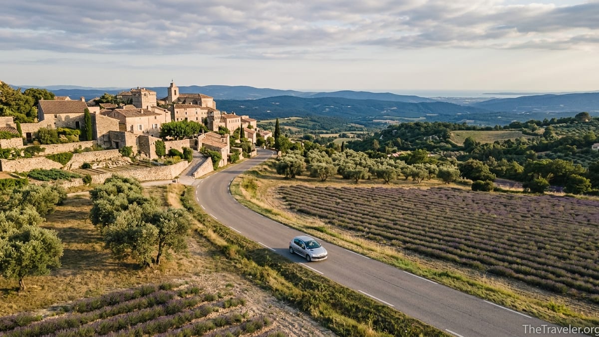
Provence is best explored on local roads that string together compact villages and market towns. A classic base is Avignon or L’Isle-sur-la-Sorgue, where you can pick up a car at the station and make day trips to the Luberon. A typical loop might be Avignon to Gordes, Roussillon and Bonnieux, with visits to spots such as the ochre trail at Roussillon and viewpoints over Sénanque Abbey’s lavender fields in June and early July.
Roads here are narrow in places but generally well surfaced. The climb from the valley near Fontaine-de-Vaucluse up toward Gordes, for example, winds through olive groves and stone farmhouses before delivering sweeping views of the perched village. Distances are short: Gordes to Roussillon is roughly a short drive, but traffic and photo stops mean you rarely travel at full speed. Many travelers comfortably visit three villages and a market in one day, provided they start early.
To extend into deeper countryside, continue east to the Plateau de Valensole and on to Moustiers-Sainte-Marie and the Verdon Gorge. The D952 road above Lac de Sainte-Croix and the Route des Crêtes along the gorge rim offer some of the most dramatic driving in southern France, with hairpin bends and frequent viewpoints. Smaller cars feel more manageable on these roads, and drivers prone to vertigo may prefer to stop often at lay-bys rather than stare down from every balcony.
Village parking in Provence usually involves outdoor gravel lots. In high lavender season, popular spots like Valensole fields, Sénanque Abbey or Sault can be busy by mid-morning. Arriving before 9 am not only simplifies parking but also means softer light for photography and cooler walking temperatures. Evenings are pleasant for slow drives back via less direct scenic routes, when most tour buses have left and village restaurants open for dinner.
Côte d’Azur and the Corniches: from Cassis to Menton
The Côte d’Azur combines fast autoroutes just inland with iconic scenic roads running closer to the coast. West of Toulon, drivers often base themselves in Cassis or La Ciotat to explore the calanques and the Route des Crêtes, a cliff-top road between Cassis and La Ciotat that offers views over the Mediterranean and vertiginous drops. Sections of this route can close in high wind, so it is worth asking locally before setting out.
Farther east, between Nice and Menton, three “Corniche” roads climb the cliffs above the sea. The Basse Corniche runs closest to the water through Villefranche-sur-Mer and Beaulieu, the Moyenne Corniche cuts through villages like Èze with wide sea views, and the Grande Corniche follows an older, higher route with sweeping panoramas and tight bends. Many visitors choose to drive one Corniche in one direction and return on another, for example heading out from Nice on the Moyenne Corniche to Èze and returning on the Basse Corniche via the waterfront.
Traffic along the Riviera can be dense in July and August, particularly near Nice, Cannes and Monaco, and during major events. When time is limited, some travelers use the A8 motorway to cover distance quickly between, say, Aix-en-Provence and Nice, then drop down to the coast for slower scenic sections. Even short hops, such as Antibes to Cannes, can take longer than the map suggests once you factor in lights, roundabouts and summer holiday congestion.
Parking along the Côte d’Azur is typically paid and controlled. In Antibes, underground lots near the old town allow you to walk to the marina and historic lanes. In Cassis, a park-and-ride style lot on the hill above town often proves easier than chasing spaces closer to the harbor. Beach towns such as Fréjus or Saint-Raphaël have a mix of street parking and municipal car parks, with prices usually rising the closer you get to the water.
Camargue and Mediterranean wetlands: Arles, Saintes-Maries and Aigues-Mortes
South of Arles, the Rhône delta opens into the Camargue, a landscape of salt marshes, lagoons, flamingos and semi-wild white horses. Driving here feels very different from the enclosed valleys of the Luberon or the crowded Riviera. Roads are long, flat and straight, flanked by rice fields and reed beds, and the horizon is wide. Many visitors base themselves in Arles or the seaside town of Saintes-Maries-de-la-Mer to explore the region by car, with short detours on foot or bicycle.
From Arles to Saintes-Maries-de-la-Mer is roughly under an hour by car, depending on traffic. Near Saintes-Maries, you will find several signed parking areas behind the seafront and near the church. During busy dates, especially in late May when a major pilgrimage draws large crowds to the town, it is wise to arrive early and be patient with marshalled parking. Inland tracks and dykes are often closed to general traffic to protect the nature reserve, so obey signs and avoid driving off-road.
Another appealing target is Aigues-Mortes, a medieval walled town to the west of the delta, accessible via local roads from Arles or Nîmes. Here you can park outside the ramparts and walk through the gates into a grid of narrow streets. Short drives connect Aigues-Mortes with nearby salt pans and beaches such as Le Grau-du-Roi or Espiguette, where larger open-air lots serve swimmers and kite-surfers.
The Camargue rewards slow travel. Many drivers park near observation points to watch birds at sunrise or sunset, then continue along minor departmental roads toward small hamlets and manades, traditional horse and bull farms that sometimes offer visits and meals. Because distances are deceptive across such open land, it is easy to underestimate driving times back to Arles, Nîmes or Montpellier, so schedule your return before dark if you are unfamiliar with the roads.
Occitanie’s backroads: Carcassonne, Gorges and Cathar country
Occitanie stretches from the Mediterranean to the Pyrenees and up into hill country and river gorges. Many trips start in Toulouse or Montpellier, with travelers picking up a car to reach smaller historic centers such as Albi, Carcassonne, Narbonne or Béziers. A popular driving triangle links Toulouse, Albi and Carcassonne, combining a major city, a red-brick cathedral town and a double-walled medieval citadel, using a mix of autoroutes and smaller routes.
Carcassonne is a natural hub for road trips. You can approach via the A61 motorway from Toulouse or Narbonne and then follow signs for the “Cité médiévale,” where several car parks line the base of the upper town. From there, shuttle buses or a short uphill walk lead you into the fortified core. Many visitors stay outside the walls, either in the lower town or countryside gites, and drive in for evening strolls when day trippers have left.
From Carcassonne, it is a straightforward drive south to the Corbières hills and Cathar castles, including sites such as Peyrepertuse and Quéribus, or west toward Limoux and the upper Aude valley. The roads are narrower and twistier here, climbing through vineyards and limestone ridges, with frequent viewpoints. Drivers used to motorways should allow generous time between stops; a route that looks short on the map can easily take a couple of hours once you factor in bends and photo breaks.
Elsewhere in Occitanie, established driving itineraries connect river gorges and high plateaus, such as routes around the Gorges du Tarn and the Causses. These trips often use national roads with limited overtaking opportunities, so keeping to moderate speeds and stopping regularly at village cafés is both safer and more enjoyable. The rewards include stone-built villages, viewpoints over deep canyons and easy side trips to Roman sites like the Pont du Gard between Nîmes and Uzès.
Optional southwest extensions: from Carcassonne to Toulouse and the Atlantic
Travelers with two weeks or more can extend a southern France road trip into the southwest, linking Occitanie with the Atlantic coast and wine regions. A natural continuation from Carcassonne is to follow the A61 toward Toulouse, then decide whether to head further west toward Auch and the rolling countryside of the Gers, or northeast toward Cahors and the Lot Valley. Each direction offers quieter roads than the Riviera, with patchworks of vineyards, sunflower fields and small bastide towns.
From Toulouse, some itineraries swing north toward Montauban and then west to Agen, before joining roads to Bordeaux. This connects the pink-brick architecture of Toulouse with the vineyards of Bordeaux and the dunes and beaches around Arcachon. Drivers uninterested in large cities may instead bypass Bordeaux and aim directly for coastal areas such as the Bassin d’Arcachon or the long sandy strand south toward Biscarrosse, where beach parking lots sit behind pine forests.
Another option is to stay closer to the Pyrenees, using Tarbes, Pau or Foix as bases. Mountain roads here require more concentration, with passes that can be snow-affected outside late spring to early autumn. In summer, though, they provide dramatic driving combined with walking and small spa towns. This southwestern arc pairs well with a return route through the Armagnac and Madiran wine areas, where you can stay in guesthouses and visit estates, provided one person in the party is prepared to limit tastings before driving.
One practical consideration for southwest extensions is the cumulative cost of tolls. The autoroutes linking Toulouse, Bordeaux and Bayonne are efficient but carry regular toll sections. Travelers on a tighter budget often choose to leave the motorway after major junctions and follow national roads, which link many of the same towns more slowly but more scenically, passing through weekly markets and village squares rather than service areas.
Suggested 7, 10 and 14 day driving circuits
For a 7 day circuit focused on Provence and the Côte d’Azur, one workable outline is to arrive by train to Avignon TGV and pick up a car there. Spend two nights in or near Avignon, using one full day to drive a Luberon loop through Gordes, Roussillon and Bonnieux. Then drive via Aix-en-Provence to Cassis for two nights, allowing time for the Route des Crêtes and a boat trip among the calanques. Finish with two nights around Nice or Antibes, exploring at least one of the Corniche roads and dropping the car at Nice Airport or Nice-Ville station before onward travel.
A 10 day itinerary might add the Camargue and a taste of Occitanie. One version begins in Marseille or Avignon for two nights, continues with two nights in the Luberon, then spends two nights in Arles or Saintes-Maries-de-la-Mer to explore the Camargue. From there, drive west toward Montpellier and Beziers before reaching Carcassonne for two nights, then return the car in Toulouse and spend the final night without a vehicle. This route combines village lanes, coastal wetlands, vineyards and a fortified city, with driving days generally under four hours.
With 14 days, you can comfortably link Provence, the Côte d’Azur, Camargue, Occitanie and a southwest extension. A sample loop could start in Nice with three nights on the Riviera, then continue to the Verdon Gorge and Luberon villages for four nights split between Moustiers-Sainte-Marie and L’Isle-sur-la-Sorgue. Next, spend two nights around Arles or Nîmes for the Camargue and Roman sites, then drive to Carcassonne for three nights to explore the citadel and Cathar country. Finish with two nights in Toulouse or the Gers countryside before flying out or taking a train back to Paris.
When planning your own circuit, remember that check-in and check-out times effectively shorten each day. A realistic pattern is to alternate heavier driving days, such as Nice to Moustiers or Carcassonne to Toulouse, with gentler days where you only drive short loops and spend more time walking villages. Booking at least some stays with on-site parking, particularly for city stops like Avignon, Nîmes or Toulouse, makes transitions significantly easier.
The Takeaway
A southern France road trip rewards thoughtful planning more than obsessing over every detail. Choosing a practical car, understanding how tolls and parking work, and allowing enough time for slower scenic roads will matter more to your comfort than ticking off an extra village. By combining Provence’s hill towns, the dramatic corniche drives of the Côte d’Azur, the open horizons of the Camargue and the layered history of Occitanie, you can create a journey that feels both varied and coherent.
Whether you have a week, ten days or a full two weeks, the key is to link a few strong bases by relatively short drives and then explore out-and-back from each. Using Avignon, Cassis or Nice, Arles or Saintes-Maries, and Carcassonne or Toulouse as anchors keeps logistics simple. Beyond that, leave space for detours. Some of the most memorable moments on these roads come from an unplanned stop at a village café, a quiet viewpoint over lavender fields or a last-minute decision to follow a smaller road along a river gorge.
FAQ
Q1. Do I really need a car to explore Provence and the Côte d’Azur?
Many key towns are linked by train and bus, but a car gives far more flexibility for hilltop villages, Verdon Gorge viewpoints and smaller Riviera coves, especially outside peak summer schedules.
Q2. Is it better to start my road trip in Nice, Marseille or Toulouse?
Nice works well if you want a Riviera focus, Marseille or Avignon suit Provence and the Camargue, while Toulouse is ideal for Occitanie and southwest extensions; your choice depends on which regions interest you most.
Q3. How stressful is driving the Corniche roads above the Côte d’Azur?
The Corniche roads are winding and occasionally narrow but well maintained; confident drivers in compact cars usually find them manageable if they avoid peak rush hours and allow faster locals to pass when possible.
Q4. When is the best time of year for a southern France road trip?
Late April to June and September to early October usually offer mild weather, quieter roads and more available parking, while July and August are busier and hotter but lively with festivals and long evenings.
Q5. How much should I budget for tolls and fuel on a 10 day trip?
Costs vary widely by route and driving style, but many travelers find that tolls and fuel together add up to a noticeable but manageable portion of their budget, especially if they mix motorways with slower free roads.
Q6. Is parking difficult in popular villages like Gordes or Roussillon?
Parking is usually well organized but limited in high season; arriving before mid-morning or later in the evening makes finding a space much easier and often more pleasant for exploring on foot.
Q7. Can I drive a rental car into small medieval centers in Occitanie?
Some historic cores, such as the Cité of Carcassonne, are largely pedestrian or restricted, so it is common to park in designated lots outside the walls and walk or use shuttles to enter.
Q8. Are the Verdon Gorge and mountain roads safe for nervous drivers?
They are generally safe and well maintained, but they have sheer drops and tight bends; nervous drivers can choose shorter sections, avoid the highest balcony roads and take frequent breaks at viewpoints.
Q9. How far in advance should I book accommodation with parking?
In busy months it is sensible to book several months ahead in hotspots like the Luberon, Nice and Cassis, specifically checking that your chosen hotel or rental includes on-site or nearby parking.
Q10. Is it realistic to combine Provence, Côte d’Azur, Camargue and Occitanie in one week?
It is possible but rushed; most travelers will enjoy the trip more by focusing on two or three of these areas in seven days and saving the others for a longer future circuit.